CNES/BT article published in BT.
A map is a drawn document. It is an abstract representation of reality, on a reduced
scale, with its own conventions of colours and symbols to make interpretation easier.
The high resolution of SPOT images has led to the development of new map products,
known as spatellite image maps. A satellite image map is a map which uses an underlay of
one or more satellite images corrected for imperfections due to the viewing mode.
Complementary information from conventional maps or other sources is then added.
In its final form, a satellite image map also includes :
- along its frame,the usual annotations (coordinates, scale,
direction of true and magnetic north, etc.)
- enhancements (place names, contours, administrative
boundaries, roads, rivers, etc.),
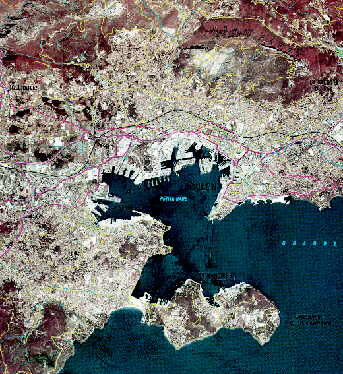
| Extract of the satellite
image map, Toulon toposheet, made from SPOT images taken on 14 July and 18 August
1993 with enhancements from the IGN's Carto® cartographic data base. Intial scale before
reduction = 1 : 50 000. Under the
registered trademarks "SPOTView® BD Carto®", the Institut Géographique
National (IGN) and Spot Image produce satellite image maps which are available in analogue
(film, paper) and digital forms (computer files).
click to enlarge (83 kb ) |
|
Satellite image maps are made for professionals who can interpret the colours and
sometimes strange features of satellite images. They are used for the following
applications :
- "emergency"mapping, which involves making maps of regions for which little
geographic information is available, in a relatively short time,
- updating conventional maps (in particular for developing countries),
- cartography for projects for thematic maps, highlighting
specific information, for instance natural resources or irrigated land.
top of page, article
BT n°1082 : Bibliothčque de
Travail -
Published by the PUBLICATIONS DE L'ECOLE MODERNE FRANCAISE
06376 MOUANS SARTOUX CEDEX - Tél. : 04 92 92 17 57

page updated on the 06 June 2000