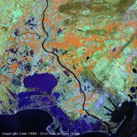
Copyright CNES - 1998 - Spot Image distribution
This image was taken on 4 April 1998 at 10 h 27 min 12 sec (UTC).
The scene comes from imagery acquired by HRVIR instrument no. 1, over the city of
Arles (France).
The geographic coordinates of its centre point are 43°37'17' latitude north and
004°37'41" longitude west.
Here is a preview of the image:
| Copyright CNES - 1998 - Spot Image distribution |
| Complete subsampled image |
Three types of enlargement are possible:
The digital product shown consists of the red (B2/M), near infrared (B3/XS3) and shortwave infrared (B4/SWIR) spectral bands. The B2 band has a 10m resolution while the other bands have been resampled to this resolution.
These spectral bands are assigned to the basic colours, red, green and blue:
Shortwave infrared representation |
||
|
||
|
||
|
||
|
The cartographic representation corresponds to a projection onto a plane tangent to the
centre of the landscape image
acquired by the satellite, with the top of the image pointing towards the north.
![]()
page updated on the 00-06-06