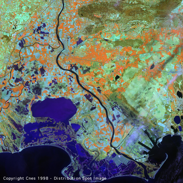
This SPOT 4 image represents the lower Rhone valley (France) and its delta on the Mediterranean.
The scene covers an area of approximately 60 km x 60 km, from the southern limits of the city of Orange (right at the top) to the shores of the delta and the town of Saintes-Mairies de la Mer (right at the bottom); to the left, on the western edge of the delta, may be seen the small town of Aigues-Mortes; on the far right is the marina and part of the town of Martigues as well as the western part of the Etang de Berre (the Berre pond). The Rhone river crosses the picture from north to south. The scene covers almost the same land area as the 1:100000 Institut Gťographique National map (Green series, number 66), which is still an excellent reference.
The accuracy of SPOT 4's instruments makes it possible to identify the various elements of the landscape, down to the finest details.
It is thus possible to observe two major morphological areas, themselves consisting of several, fairly typical and composite landscapes. These are a large area to the west of the Rhone and another to the east of the Rhone. The two areas which are about the size of two half-images, are bordered on the south side by the Mediterranean sea.
To the west of the Rhone, leaving the river in a north-westerly direction, may be seen, successively, an alluvial plain which widens towards the south, then a few hills and the calcareous Causse foothills, running alongside the bed of the Gard river (or Gardon). The southern part of this large area is taken up by most of the river delta, formed by the Petit RhŰne in the west and the Grand RhŰne in the east.
To the east of the river, the landscape consists of two parts: a northern part, which is a wetlands plain in the form of a hollow plate, with circular edges, limited to the east by the Lubťron massif and to the north-east by the first Alpine foothills. This plain is aligned with the torrential (but well controlled) Durance river and the streams from its catchment basin. By contrast, in the south, we find a dry, rocky plain, with no vegetation cover, the Crau, which precedes the delta and the sea. These two different areas, which may be considered to be almost flat, given the context, are separated by the east-west Alpilles chain of mountains.
The diversity of the landscape is clearly visible due to the characteristics and performance of the optical instruments carried by SPOT 4, and also to the technical choices made when designing the Spot family of Earth observation satellites. These are: an average swath of 60 km by 60 km with a satisfactory resolution of 10 to 20 metres, as well as high radiometric precision over four spectral bands, an optimum configuration for this kind of work.
It is thus possible to observe and study the greatly varied soils and vegetation-cover, as described above, with a high degree of accuracy, whether these be the wet, muddy, sandy or reed-covered areas of the Camargue natural park (in the delta and around the Etang de VaccarŤs, for instance) or vegetation on the mountain areas (the Alpilles, and the Causses foothills), or yet again more typical populations, such as the garrigue north-east of the delta or the Crau, to the south-east.
Farmed areas are also clearly visible: rice paddies and salt works, orchards to the north and south of the Alpilles, similar in kind but with a different appearance, vineyards which have a very fine texture and the fairly homogeneous, uncultivated land of the Alpine foothills. With respect to land-cover the discriminating power of the short-wave infra-red channel is obvious.
The impact of human activity is clearly visible both in its extent and in the diversity of human pressure on the natural environment, which means that it is not difficult to grasp the ecological implications of national or regional development. The major urban and suburban areas are visible. Thus, along the river, from north to south, may be seen Avignon, a communications hub, then Arles in the centre of the scene at the apex of the delta and finally the Golfe de Fos and its port area. Also visible are its two large basins and the canal port of Port Saint-Louis on the Rhone, between the gulf and the delta. Other cities may be seen. SPOT 4 shows how Nimes, near the confluence of the Gard and the Rhone, fit in to the Roman geopolitical scheme, its location on the Roman circum-Mediterranean west-east trade route, supplied with water from the Causses (the aqueduct and the Pont du Gard), and also its orientation towards the south-east, towards Rome and the rising sun). In contrast, Martigues is located between sea and coastal marsh which already hints of a change to a more Marseillaise landscape towards the east.
SPOT 4 thus provides for each area of interest a set of unique, high-resolution global information which reveals the originality of a site such as that of the Rhone delta in the south-west of France.
![]()
page updated on the 00-06-06