| Protection of the environment has become one of the major
preoccupations of our time. The dangers which threaten the health of our planet are called
pollution, soil erosion, desertification, deforestation, etc. The phenomena involved are
complex, continually evolving, interdependent and act on a large scale. The way to
understand and control them will inevitably depend on global
monitoring.
Here again, satellites can play a leading role by regularly collecting reliable
information on the whole of the Earth's surface.
SPOT satellites can be used to inventory land use and land cover, to identify water
resources or irrigated areas, to determine the impact of such and such an activity on the
environment, to monitor coastal regions (which are often vulnerable), to follow up the
consequences of industrial accidents, to determine crop health, etc. |
click to enlarge (31 kb )
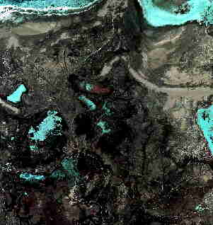 |
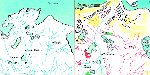 The Aral sea is shrinking |
|
| They provide developers, decision-makers, national or local government
with the means to define, at their own particular level, an environmental protection
policy. |
SPOT imagery of this landlocked
sea, taken on 2 March 1989, reveals that since 1989 the shoreline has advanced more than
20 km on the sea in some places, with the emergence of dunes (shown in yellow in the 1989
map), of salty soil and new vegetation, etc. This ecological disaster has been caused by
massive drawing of water from the Amou-Daria river. |