CNES/BT article published in BT.
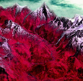
This breathtaking 3-D view of
the Arve valley, at the foot of the Mont-Blanc massif, was reconstituted from a SPOT
stereopair.
Founded in 1988, Istar (Imagerie stéréo appliquée au relief - 3D relief stereoscopic
imagery) specializes in computer mapping using aerial photographs and satellite imagery. |
| SPOT satellites can acquire stereopairs
in which the same area of the Earth's surface is seen from different angles. |
|
click to enlarge (46 kb )
|
When analysed by a computer, a stereopair provides the elevation for each picture
element (called a "pixel"). The computer file containing the elevation for each
of the pixels in an image, when projected into a cartographic reference frame, is called a
digital elevation model (DEM).
This relief information is very useful. In can be used in particular :
- to correct each SPOT scene in order to create an ortho-image,
which can actually be superimposed on a map at the same scale,
- to create a three dimensional relief map.
It may be applied in particular to :
- telecommunications, to determine the best sites for relays for a future cellular
telephone network,
- petroleum or mineral prospecting, to obtain a global view of a site and its geographical
features (faults, erosion, etc.), information which is necessary for preliminary studies,
- for public works (determining the best route for a highway, or a track for a high-speed
train or TGV, etc.)
- for defence, to prepare missions and simulate an aircraft's flight over a region.
top of page, article
BT n°1082 : Bibliothčque de
Travail -
Published by the PUBLICATIONS DE L'ECOLE MODERNE FRANCAISE
06376 MOUANS SARTOUX CEDEX - Tél. : 04 92 92 17 57

page updated on the 06 June 2000