Direct
receiving stations
Archive and Preprocessing
Centre
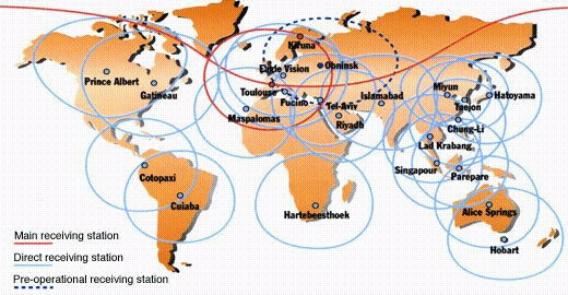
Worldwide, over 20 receiving stations access the SPOT system on a daily basis. They receive and process imagery gathered by the operational SPOT satellites (currently SPOT 1 and SPOT 2).
This map shows the stations and their "acquisition circles". A station can receive imagery whenever a satellite is within its acquisition circle.
![]()
In preparation for SPOT 4's entry into service, CNES set up the archive
and preprocessing centre (CAP) on Spot Image premises.
The CAP, produced by MS&I and operated by Spot Image, was commissioned in August 1995.
Every day it processes image data from the operational SPOT satellites. Designed from the
outset to handle data flows from three spacecraft at once, the CAP is ready to process the
first images returned by SPOT 4.
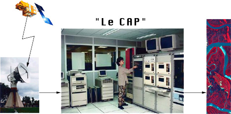
The CAP in the SPOT acquisition chain
The image telemetry received by receiving stations cannot be converted directly into
usable imagery. It is the CAP's job to make the imagery accessible to users.
This involves two tasks : inventorying and production.
 Inventorying
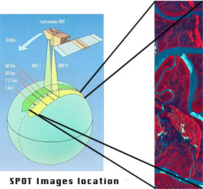
involves determining the area covered by the image telemetry, then framing the 60-km-wide
data strips acquired by an HRV or HRVIR instrument into scenes. Each scene is then
assessed for cloud-cover, snow and radiometric quality.
Inventorying
involves determining the area covered by the image telemetry, then framing the 60-km-wide
data strips acquired by an HRV or HRVIR instrument into scenes. Each scene is then
assessed for cloud-cover, snow and radiometric quality.
The resulting data and "quick-looks" are then loaded into the Dali
catalogue containing reference data on all scenes acquired by SPOT satellites. The raw
data are stored in the SPOT archive.
 The
SPOT archive contains all the scenes acquired by the successive SPOT satellites since
SPOT 1 was launched in February 1986.
The
SPOT archive contains all the scenes acquired by the successive SPOT satellites since
SPOT 1 was launched in February 1986.
Until 1995, image telemetry downloaded during passes over the Aussaguel station near Toulouse were stored on high-density digital tapes (HDDTs) holding 7 Gbytes each. Today, the CAP's physical archive contains over 15 000 HDDTs corresponding to 15 000 SPOT passes.
 Since 1995, image telemetry has been stored on type-D1 cassettes. These
employ a helical recording technique similar to that used by VCR recorders and offer about
ten times the capacity of HDDTs. Today, the CAP's physical archive contains 1500 type-D1
cassettes.
Since 1995, image telemetry has been stored on type-D1 cassettes. These
employ a helical recording technique similar to that used by VCR recorders and offer about
ten times the capacity of HDDTs. Today, the CAP's physical archive contains 1500 type-D1
cassettes.
The HDDTs and D1 cassettes in the CAP's physical archive represent over 20 000 SPOT passes, or over 50 Terabytes of image data (1 Tbyte = 1 million megabytes).
CNES is responsible for managing and conserving the physical archives. After teaming up with the IGN (Institut Géographique National), CNES launched a programme to store the entire archive first on optical tape, then on digital cartridges.
Preprocessing involves converting the image data (recorded on HDDTs and other media) into standard SPOT products. More specifically, it involves applying radiometric and geometric corrections to raw image data. Several levels of correction have been defined. Preprocessed imagery can be delivered on computer-compatible tape (CCT), CD-Rom, or photographic media (film, etc.).
The CAP performs so-called "system preprocessing" to levels 1A and 1B. These two levels of preprocessing are designed to compensate for the instrument transfer function (for radiometric corrections) and SPOT geometric imaging conditions and the satellite's orbital motion (for geometric corrections).
Level-1A preprocessing leaves the data in raw form, save for radiometric corrections. Level-1A data are intended primarily for users requiring image data that have undergone only minimal preprocessing.
Corrections:
Level-1A products are supplied with the following auxiliary data:
satellite,
instrument,
spectral band(s),
Grid Reference System (GRS) designators for scene centre,
time and date of acquisition,
preprocessing level,
angle of incidence and scene orientation,
geographic reference marks for corners of scene,
distance between scene centre and nearest GRS node,
Sun azimuth and elevation.
reference marks by pixel column and line numbers,
latitude and longitude,
satellite's residual angular rates,
viewing angles at each end of scanline.
gains applied to each spectral band during scene acquisition,
CCD detector dark current values,
CCD detector normalization coefficients,
absolute calibration coefficients,
pixel count histograms,
spectral profiles of scene's spectral bands,
dynamic range enhancement (method and threshold values).
Products preprocessed to level 1A are used primarily for mapping, stereorestitution and special radiometric studies. Stereopairs preprocessed to level 1A can be used directly for stereo viewing.
Products preprocessed to level 1A are available as full or quarter scenes.
The volume of a full standard scene is fixed at 6000 rows of 6000 pixels each in the panchromatic mode, or 3000 rows of 3000 pixels in each of the three bands making up the multispectral mode, irrespective of the viewing angle.
Level-1A products are distributed on the same media and using the same data format as SPOT digital scenes.
Level-1B is the basic preprocessing level including both radiometric and geometric corrections. These corrections compensate for effects due to the viewing conditions and satellite/Earth system.
Radiometric corrections are the same as for level-1A preprocessing.
Geometric corrections compensate for systematic effects, including : panoramic distortion, Earth's rotation and curvature, and variations in the satellite's orbital altitude relative to the reference ellipsoid. Geometric corrections fully compensate panoramic distortion.
Level-1B products are expected to offer a location accuracy of 500 metres (rms error) for vertical-viewing and a relative internal error for distances of 0.5 x 0.001 (rms).
Basic product. Level-1B products are used primarily for photointerpretation and thematic studies. Image analysis can be visual, computer assisted or all-digital.
Level-1B stereopairs can be used directly for stereo viewing.
Level-1B products are available as full or quarter scenes.
Each scene is resampled to yield pixels either 10 or 20 metres square, depending on the spectral mode (panchromatic or multispectral). On request, scenes can also be oversampled to 7.5 m or 15 m.
Resampling is required because oblique viewing results in pixel distortion in the cross-track, or East-West direction. As a result of resampling, the number of pixels in a level-1B scene differs from that in a raw scene. While the number of rows remains unchanged, the number of pixels per row ranges from 6,400 to 8,500 in panchromatic mode and from 3,200 to 4,250 (per spectral band) in multispectral mode, depending on the viewing angle, corresponding to 60 km in the North-South direction by 60 to 80 km in the East-West direction.
Level-1B products are distributed on the same media and use the same data format as SPOT digital scenes.
![]()
page updated on the 04-09-29